Sélection de la langue

Search

Sommaire du brevet 2967629 

Énoncé de désistement de responsabilité concernant l'information provenant de tiers

Une partie des informations de ce site Web a été fournie par des sources externes. Le gouvernement du Canada n'assume aucune responsabilité concernant la précision, l'actualité ou la fiabilité des informations fournies par les sources externes. Les utilisateurs qui désirent employer cette information devraient consulter directement la source des informations. Le contenu fourni par les sources externes n'est pas assujetti aux exigences sur les langues officielles, la protection des renseignements personnels et l'accessibilité.

Disponibilité de l'Abrégé et des Revendications

L'apparition de différences dans le texte et l'image des Revendications et de l'Abrégé dépend du moment auquel le document est publié. Les textes des Revendications et de l'Abrégé sont affichés :

  • lorsque la demande peut être examinée par le public;
  • lorsque le brevet est émis (délivrance).
(12) Demande de brevet: (11) CA 2967629
(54) Titre français: SYSTEME DE COLLECTE, TRAITEMENT, VISUALISATION ET ANALYSE DE DONNEES SISMIQUES EN SOUS-SURFACE, DE SISMICITE, DE VIBRATION DU SOL, DE DONNEES TOPOGRAPHIQUES INTEGRES LARGE BANDE
(54) Titre anglais: SUPER BROADBAND INTEGRATED SUBSURFACE SEISMIC, SEISMICITY, GROUND VIBRATION, TOPOGRAPHIC DATA COLLECTION, PROCESSING, VISUALIZATION AND ANALYSIS SYSTEM
Statut: Réputée abandonnée et au-delà du délai pour le rétablissement - en attente de la réponse à l’avis de communication rejetée
Données bibliographiques
(51) Classification internationale des brevets (CIB):
  • G01V 01/22 (2006.01)
  • G01V 01/18 (2006.01)
  • G01V 01/24 (2006.01)
(72) Inventeurs :
  • HOWE, WILSON (Canada)
(73) Titulaires :
  • SYMROC BUSINESS AND PROJECT MANAGEMENT LTD.
(71) Demandeurs :
  • SYMROC BUSINESS AND PROJECT MANAGEMENT LTD. (Canada)
(74) Agent: GOWLING WLG (CANADA) LLP
(74) Co-agent:
(45) Délivré:
(22) Date de dépôt: 2017-05-19
(41) Mise à la disponibilité du public: 2017-08-23
Requête d'examen: 2017-06-22
Technologie verte accordée: 2017-08-23
Licence disponible: S.O.
Cédé au domaine public: S.O.
(25) Langue des documents déposés: Anglais

Traité de coopération en matière de brevets (PCT): Non

(30) Données de priorité de la demande: S.O.

Abrégés

Abrégé anglais


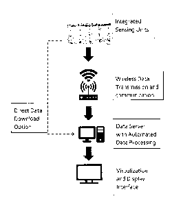
An integrated super bandwidth seismic, vibration, seismicity
monitoring and surface positioning system with wide detection
range, live surveillance, flexible survey array arrangement,
wireless data transmission, fast processing with data mining,
machine learning capacities, and fast visualization. The system
hardware can be left in the ground for a long duration. The
survey array hardware can be site operated or remotely
controlled to conduct continuous or intermittent surveys.

Revendications

Note : Les revendications sont présentées dans la langue officielle dans laquelle elles ont été soumises.


WHAT IS CLAIMED IS:
1. A monitoring system with integration of multiple functions,
capable of: monitoring earthquakes, ground vibrations, induced
seismicity, subsurface seismic survey, GPS positioning, wireless
data transmission to data server, with automated server data
processing, data mining, machine learning and pattern
recognition of the data collected. The system comprises of field
self-powered super broadband sensing units, independent
wireless data transmission, an online receiving or direct data
transfer mechanism, and a machine processing system with quick
response visualization.
2. The system of Claim 1, wherein each sensing unit has super
broadband detection range of o.00i to 420 Hz, with high signal to
noise ratio and with high accuracy to detect dynamic vibrations,
including ground vibrations, subsurface seismic waves,
earthquake signals, and induced seismicity signals.
3. The system of Claim 21 wherein each sensing unit is self-powered
with rechargeable battery.
4. The system of Claim 21 wherein each sensing unit has integrated
GPS, that can perform automatic position information updates.
5. The system of Claim 21 wherein each sensing unit has integrated
independent data recording and a data storage device that can
save detected data for either data transmission and/or data
download.

6. The system of Claim 2, wherein each sensing unit has an
integrated Analog to Digital conversion module, analog and
digital output connections.
7. The system of Claim 2, wherein each sensing unit has an
integrated clock trimming mechanism.
8. The system of Claim 2, wherein each sensing unit has an
integrated signal test generator.
9. The system of Claim 2, wherein each sensing unit has an
integrated wireless transfer unit using 3G/4G or Radio frequency
wireless data transmission method. Each sensing unit can
transmit data independently without passing signal to other
sensing units.
The system of Claim 2, wherein each sensing unit has a
wireless remote control mechanism. Each sensing unit can be
remotely switched on or off to operate either continuously or
periodically.
The system of Claim 3., wherein that the data receiving
server is online, connected to wireless data receiving
mechanisms, and has connection for direct data download.
12. The system of Claim i, wherein data processing software
has automated function using spatial autocorrelation
measurements for seismic facies analysis, and use unsupervised
2

clustering analysis on seismic facies data, with machine learning
capability for seismic and vibration wave pattern recognition. The
processed data can be displayed using time lapse or still imaging
methods in 2D or 3D format with references to ground surface
maps, underground geological structure/ formation map
information, and with interface for analysis.
3

Description

Note : Les descriptions sont présentées dans la langue officielle dans laquelle elles ont été soumises.


CA 2967629 2017-05-19
Super Broadband Integrated Subsurface Seismic, Seismicity,
Ground Vibration, Topographic Data Collection, Processing,
Visualization and Analysis System
FIELD
[000l.] The invention is an integrated multipurpose system that
generally relates to induced seismicity, ground vibration, subsurface
seismic events, surveys, and surface position dynamic changes
monitoring.
BACKGROUND
[0002] Seismic surveys are commonly used in the resource exploration
field, which commonly involves source signal generation, and
detection of the reflection or refractions of the signals. The signals are
used to generate 2D13D images or time-lapse images (4D)
[0003] Seismicity is a measure which encompasses earthquake
occurrences, mechanisms, and magnitude at a given geographical
location (Physics of the Earth (4 ed.). Cambridge, UK). As such, it
summarizes a region's seismic activity. Induced seismicity refers to
typically minor earthquakes and tremors that are caused by human
activity that alters the stresses and strains on the Earth's crust. Most
induced seismicity is of a low magnitude.
[0004] Ground vibrations normally refers to mostly man-made
vibrations of the ground, in contrast to natural vibrations of the Earth
studied by seismology. For example, vibrations caused by explosions,

CA 2967629 2017-05-19
=
construction works, railway and road transport, etc. The vibrations can
have a wide frequency range, and commonly generate waves that
travel on the ground surface.
[0005] Topography is the study of the shape and features of the
surface of the Earth and other observable astronomical objects. The
topography of an area commonly refers to the ground surface shapes.
[00 6] Various sensing mechanisms are used for detection purpose in
each of these subject areas, using various types of sensors. All the
sensing mechanisms have significant limitations, and there is no single
system that can be utilized for seismic survey, induced seismicity
monitoring, ground vibration monitoring, topographic survey,
combining with continuous operations, wireless data transfer,
automatic data processing and visualization capabilities all together.
[0007] This invention is the first system that provides all these
combined functionalities and capabilities.
SUMMARY
[0008] This invention comprises of super broadband, integrated
sensing units to detect dynamic seismic signals, seismicity, vibration
signals, and GPS signals all together. Each field sensing unit has a
super bandwidth (o.00l. -420 Hz) with the capability to detect low
frequency seismicity, mid-range and high frequency seismic and
vibration signals, creating a super broadband detection range all within
each integrated sensing unit. The sensing units are installed in the
application areas individually or with an independent array
arrangement. With array arrangement, each sensing unit retains
independent operation. The sensing units can be field operated or
2

CA 2967629 2017-05-19
remotely controlled to continuously or intermittently collect, store,
and transmit integrated data to an online server for automatic data
processing, recognition, and generate visualization with an integrated
map interface.
BRIEF DESCRIPTION OF DRAWINGS
[wog] FIG.1 is a photograph of an integrated sensing unit, with super
bandwidth high accuracy detection sensor suitable for seismic,
seismicity and vibration signals detection, with self-power, self-
temperature detection adjustment, integrated GPS, built-in analog to
digital signal conversion, integrated data storage, and wireless
transmission mechanism.
[ooio] FIG.2 is a processing illustration of the system. The integrated
sensing units are installed in the application field, and continuously or
intermittently operate to collect field data. Each sensing unit is
operated independently and can wirelessly transmit collected data to
an online server. The sensing units are not connected to each other in
the field. The sensing units can be repositioned freely, with integrated
GPS to automatically collect new positioning information.
[ooil] The sensing units send data sets wirelessly to an online server
for processing. The sensing units have an optional operation to collect
and store data in each sensing unit. The stored data can be directly
downloaded to the server through a physical connection on each
sensing unit.
[0012] The system software uses automated functions to process
received data with built in processing algorithms. The system software
differentiates between signal components to separate subsurface
3

CA 2967629 2017-05-19
seismic events, seismicity events, and ground vibration events. The
processed data is used to combine with each sensing unit's GPS data to
generate visualization and display With 2D, 3D, or motion images, with
map reference interface. The visualization combines surface
topography with underground events location information and
subsurface structure information.
[0003.3] FIG.3 is a photograph that shows the physical connection on
each sensing unit. The connection is used for power recharge
connection, additional battery pack connection/external solar panel
connection, and direct data download connection.
DETAILED DESCRIPTION
[0014] The general system process follows a general sequence of field
sensing, wireless data transmission, automated data processing,
visualization and display
SENSING UNITS
[0015] Field sensing starts with installation of minimum of one
integrated sensing unit. Each integrated sensing unit has high accuracy
to detect dynamic seismic signals, seismicity and vibration waves with
superior broad bandwidth. Key sensor technical specifications are
Bandwidth: o.oiHz ¨ 42oHz, Ripples in bandwidth: <+/-0.2db,
Maximum phase distortion: <0.75 degree, System dynamic range: 120
dB, Total harmonic distortion: <0.075%. Installation can be on ground
surface or buried underground. The integrated sensing units can also
be lowered into wells or submerged under water.
4

CA 2967629 2017-05-19
[0016] Each integrated sensing unit has built-in analog to digital
converter, self-temperature monitoring and adjustment, built-in signal
quality control, built-in clock trimming, built-in power reserve, built-in
data storage device, integrated wireless data transmission/
communication module, and integrated GPS module.
[00171 Each integrated sensing unit has a built-in battery reserve that
can sustain long periods of operations without recharging. Each
integrated sensing unit can be remotely turned on or off through the
built-in wireless data transmission and communication module.
[ooi.8] Multiple integrated sensing units can form an array when
required. However, each integrated sensing unit operates
independently, without the need to be connected to other sensing
units. Each integrated sensing undwirelessly communicates with an
online data server without passing data to other sensing units.
WIRELESS DATA TRANSMISSION
[0019] Each integrated sensing unit collects data during operations,
saves the data to built-in storage device and transmits the data
through the built-in wireless data transmission and communication
module.
[0020] Wireless data transmission is based on 3G/4G/5G wireless
technology or Bluetooth technology, depending on operation location
distance and communications infrastructure availability in the region.
[0023] In a situation that wireless data transmission is not ideal or not
permitted in the application area, direct data download can be

CA 2967629 2017-05-19
performed on each integrated sensing unit for data transfer from time
to time
AUTOMATED MACHINE DATA PROCESSING
[0022] After installation of the integrated sensing units in the
application area, the system is first turned on to record a period of
ambient signals, prior to detection of target signals. The signal data set
is transmitted to online automatic data processing server to set
ambient signal pattern baseline. The baseline period is selected to
reflect normal ambient condition prior to detection of any target
signals. In the example of induced seismicity monitoring, a "quiet"
period is selected from the recorded data, when no earthquake related
seismicity events or similar noises occurred.
[0023] For passive seismic and seismicity monitoring or ground
vibration detection, the integrated sensing units operate and transmit
data continuously or intermittently with preset programs, or by
manual control.
[0024] For active seismic survey, signal source is required. The
integrated sensing units can receive signals from conventional sources,
e.g. signals from vibroseis, explosives, etc. or, unconventional sources
such as vibrations from underground steam injectors, by positioning
one integrated sensing unit on a section of steel piping connected to
the steam injector, and performing correlation deconvolution to filter
source signal and related reflection, and refraction signals for data
processing and analysis.
[0025] The system software for automated processing use SOM (self-
organized mapping) based clustering analysis on seismic facies data
6

CA 2967629 2017-05-19
monitoring. The process uses unsupervised clustering to process
seismic facies analysis by combining different seismic attributes
through pattern recognition algorithms. The software has spatio-
temporal correlation and association rule for data mining algorithms,
and identifies correlations and association relationships among key
factors.
[0026] The system software for automated processing function uses
two categories of spatial correlation measures. 3.. From geostatistics
perspective. 2. From the spatial entropy perspective. Built-in spatial
index data structures are used for spatial correlation calculations.
Clustering methods includes partition clustering, hierarchical
clustering, density-based clustering, and grid-based clustering
methods.
[0027] The system software for automated machine data processing
has built-in machine learning capability for pattern recognition.
Recognized signal data patterns will be treated with less processing
steps, software automated processing will test hypotheses and apply
learned results for the same patterns if the hypothesis tests pass.
VISUALIZATION AND DISPLAY
[0028] The system software provides multi-interface for visualization
and display. The processed data with spatial information is visualized
and displayed in 2D, 3D, or motion imaging visualization, with visual
reference to surface maps, subsurface maps and geological
information systems, with display adjustment and analysis capabilities.
7

CA 2967629 2017-05-19
[0029] All figures, photos, numbers are illustration examples. The
shape, configuration, sequencing, and process description details of
the hardware and software may vary depending on the application and
environment. Variations, substitutions and changes may occur for
those skilled in the areas, without departing from the invention
disclosed.
8

Dessin représentatif
Une figure unique qui représente un dessin illustrant l'invention.
États administratifs

2024-08-01 : Dans le cadre de la transition vers les Brevets de nouvelle génération (BNG), la base de données sur les brevets canadiens (BDBC) contient désormais un Historique d'événement plus détaillé, qui reproduit le Journal des événements de notre nouvelle solution interne.

Veuillez noter que les événements débutant par « Inactive : » se réfèrent à des événements qui ne sont plus utilisés dans notre nouvelle solution interne.

Pour une meilleure compréhension de l'état de la demande ou brevet qui figure sur cette page, la rubrique Mise en garde , et les descriptions de Brevet , Historique d'événement , Taxes périodiques et Historique des paiements devraient être consultées.

Historique d'événement

Description Date
Demande non rétablie avant l'échéance 2018-12-07
Inactive : Morte - Aucune rép. dem. par.30(2) Règles 2018-12-07
Requête pour le changement d'adresse ou de mode de correspondance reçue 2018-06-11
Inactive : Avancement d'exam (OS)-Verte - Révoquée 2018-02-20
Exigences relatives à la révocation de la nomination d'un agent - jugée conforme 2017-12-11
Inactive : Lettre officielle 2017-12-11
Exigences relatives à la nomination d'un agent - jugée conforme 2017-12-11
Inactive : Abandon. - Aucune rép dem par.30(2) Règles 2017-12-07
Lettre envoyée 2017-12-01
Demande visant la révocation de la nomination d'un agent 2017-11-23
Inactive : Transfert individuel 2017-11-23
Demande visant la nomination d'un agent 2017-11-23
Inactive : Dem. de l'examinateur par.30(2) Règles 2017-09-07
Inactive : Rapport - Aucun CQ 2017-09-07
Demande publiée (accessible au public) 2017-08-23
Avancement de l'examen jugé conforme - verte 2017-08-23
Lettre envoyée 2017-08-23
Inactive : Page couverture publiée 2017-08-22
Inactive : Lettre officielle 2017-06-28
Lettre envoyée 2017-06-27
Inactive : Avancement d'examen (OS) 2017-06-27
Toutes les exigences pour l'examen - jugée conforme 2017-06-22
Exigences pour une requête d'examen - jugée conforme 2017-06-22
Inactive : Avancement d'examen (OS) 2017-06-22
Requête d'examen reçue 2017-06-22
Inactive : Lettre officielle 2017-06-19
Inactive : Correspondance - Formalités 2017-06-14
Inactive : Certificat dépôt - Aucune RE (bilingue) 2017-06-09
Exigences de rétablissement - réputé conforme pour tous les motifs d'abandon 2017-06-07
Inactive : CIB attribuée 2017-05-26
Inactive : CIB en 1re position 2017-05-26
Inactive : CIB attribuée 2017-05-26
Demande reçue - nationale ordinaire 2017-05-25
Déclaration du statut de petite entité jugée conforme 2017-05-19

Historique d'abandonnement

Il n'y a pas d'historique d'abandonnement

Historique des taxes

Type de taxes Anniversaire Échéance Date payée
Taxe pour le dépôt - petite 2017-05-19
Requête d'examen - petite 2017-06-22
Enregistrement d'un document 2017-11-23
Titulaires au dossier

Les titulaires actuels et antérieures au dossier sont affichés en ordre alphabétique.

Titulaires actuels au dossier
SYMROC BUSINESS AND PROJECT MANAGEMENT LTD.
Titulaires antérieures au dossier
WILSON HOWE
Les propriétaires antérieurs qui ne figurent pas dans la liste des « Propriétaires au dossier » apparaîtront dans d'autres documents au dossier.
Documents

Pour visionner les fichiers sélectionnés, entrer le code reCAPTCHA :


Pour visualiser une image, cliquer sur un lien dans la colonne description du document. Pour télécharger l'image (les images), cliquer l'une ou plusieurs cases à cocher dans la première colonne et ensuite cliquer sur le bouton "Télécharger sélection en format PDF (archive Zip)" ou le bouton "Télécharger sélection (en un fichier PDF fusionné)".

Liste des documents de brevet publiés et non publiés sur la BDBC .

Si vous avez des difficultés à accéder au contenu, veuillez communiquer avec le Centre de services à la clientèle au 1-866-997-1936, ou envoyer un courriel au Centre de service à la clientèle de l'OPIC.


Description du
Document 
Date
(aaaa-mm-jj) 
Nombre de pages   Taille de l'image (Ko) 
Description 2017-05-18 8 273
Abrégé 2017-05-18 1 15
Dessins 2017-05-18 3 298
Revendications 2017-05-18 3 72
Dessin représentatif 2017-07-26 1 13
Courtoisie - Lettre d'abandon (R30(2)) 2018-01-17 1 166
Accusé de réception de la requête d'examen 2017-06-26 1 177
Certificat de dépôt 2017-06-08 1 202
Courtoisie - Certificat d'enregistrement (document(s) connexe(s)) 2017-11-30 1 101
Lettre de courtoisie 2017-06-06 2 67
Correspondance reliée aux formalités 2017-06-13 2 31
Courtoisie - Lettre du bureau 2017-06-18 1 41
Requête d'examen 2017-06-21 1 25
Modification / réponse à un rapport 2017-06-21 2 42
Courtoisie - Lettre du bureau 2017-06-27 1 41
Avancement d'examen (OS) 2017-06-26 2 65
Courtoisie - Requête pour avancer l’examen - Conforme (verte) 2017-08-22 1 53
Demande de l'examinateur 2017-09-06 4 201
Changement de nomination d'agent 2017-11-22 2 63
Courtoisie - Lettre du bureau 2017-12-10 1 28
Courtoisie - Lettre du bureau 2017-12-10 1 30
Courtoisie - Annulation de l’examen avancé (verte) 2018-02-19 1 54