Note : Les descriptions sont présentées dans la langue officielle dans laquelle elles ont été soumises.
CA 02761818 2011-11-09
WO 2010/138560
PCT/US2010/036161
SYSTEM AND METHOD FOR LOCATING A TARGET WIRELESS DEVICE
FIELD
[0001] The claimed invention generally relates to methods and systems for
locating
wireless devices.
GOVERNMENT SUPPORT
[0002] This invention was made with government support under United States
Government contract number FA8750-07-C-0192. The government has certain rights
in
the invention.
COPYRIGHT
[0003] A portion of the disclosure of this patent document contains
material that is
subject to copyright protection. The copyright owner has no objection to the
facsimile
reproduction by anyone of the patent disclosure, as it appears in the Patent
and
Trademark Office patent files or records, but otherwise reserves all copyright
rights
whatsoever.
BACKGROUND
[0004] When thinking about cyber crimes, it is common to think about
illegal
hacking into a secured computer system to view or steal information. Others
may
perhaps think about the creation of computer viruses which are then set loose
on
networks or the internet to slow down computer systems, tie up communication
bandwidth, or erase computer data. Cyber crimes have also expanded to include
a range
of activities from the stealing of internet service, to inappropriate contact
with children or
the posting of child pornography on the internet.
[0005] While law enforcement officials have become increasingly vigilant
for cyber
crimes, their ability to track down and catch cyber criminals is hampered by a
proliferation of wireless technology which is being used to access computer
networks.
For example, police officers are often able to identify illegal cyber activity
and trace it
1
CA 02761818 2011-11-09
WO 2010/138560
PCT/US2010/036161
back to a source location, for example, a street address associated with a
broadband
modem that has been linked to the cyber crime. Often, however, once the
officers
investigate the residence or business at the located street address, they find
that a wireless
access point has been installed at the location and that the people at the
residence or
business do not own or have the wireless device which was connecting to the
wireless
access point and committing the cyber crime. Once the people at that location
are
cleared, the police unfortunately do not have a way to trace the offending
device and user
which are or were connecting to the wireless access point.
[0006] With the proliferation of wireless access points and other wireless
technologies, it is becoming even easier for criminals to commit cyber crimes.
Furthermore, there is increasingly a cyber component to traditional crimes.
For example,
more criminals are taking advantage of wireless voice-over-IP technology to
have
untraceable phone calls. Even terrorists are taking advantage of wireless
technology to
detonate explosive devices. Sadly, as many as 95% of cyber crimes are believed
to go
unsolved due to such difficulties, and law enforcement officials are in great
need of tools
not only to help them identify the source of such threats, but also to locate
the
perpetrators themselves so that the criminals may be apprehended and the cyber
crimes
prevented.
[0007] Therefore, it would be very desirable to have an economical,
flexible,
potentially portable, and easy to use method and system for locating a target
wireless
device.
SUMMARY
[0008] A method for locating a target wireless device is disclosed. At
least one
directional antenna is swept through a field of view at each of a plurality of
sensing
locations. A position for each of the plurality of sensing locations is
determined. During
the sweep at each of the plurality of sensing locations, a set of signal
strength data for the
target wireless device and a set of bearing information are collected. A
plurality of lines
of bearing are determined, one from each of the plurality of sensing locations
to the target
wireless device, based on the determined position, collected set of signal
strength data,
2
CA 02761818 2011-11-09
WO 2010/138560
PCT/US2010/036161
and bearing information for each of the plurality of sensing locations. A
target location
of the target wireless device is determined based on an intersection of at
least two lines of
bearing from the plurality of lines of bearing.
[0009] An apparatus for locating a target wireless device is also
disclosed. The
apparatus has a directional antenna configured to be swept through a field of
view at each
of a plurality of sensing locations. The apparatus also has a positioning
system
configured to determine each of the plurality of sensing locations. The
apparatus also has
a compass configured to determine bearing information for the directional
antenna. The
apparatus further has a user interface. The apparatus also has a processor
coupled to the
directional antenna, the positioning system, the compass, and the user
interface. The
processor is configured to 1) collect a set of signal strength data for
transmissions
received from the target wireless device by the directional antenna during a
sweep of the
directional antenna at each of the plurality of sensing locations; 2)
determine a position
from the positioning system for each of the plurality of sensing locations; 3)
collect a set
of bearing information from the compass for each set of signal strength data;
4) determine
a plurality of lines of bearing, one from each of the plurality of sensing
locations to the
target wireless device, based on the determined position, the collected set of
signal
strength data, and collected set of bearing information for each of the
plurality of sensing
locations; 5) determine a target location of the target wireless device based
on an
intersection of at least two lines of bearing from the plurality of lines of
bearing; and 6)
display the target location on the user interface.
[00010] A system for locating a target wireless device is also disclosed.
The system
has a plurality of directional antennas, each configured to be swept through a
field of
view at one or more sensing locations. The system also has a plurality of
compasses
configured to determine bearing information for the plurality of directional
antennas.
The system further has at least one user interface. The system also has at
least one
processor coupled to the plurality of directional antennas, at least one of
the plurality of
compasses, and the at least one user interface. The at least one processor is
configured to
1) collect multiple sets of signal strength data from transmissions received
from the
target wireless device by the plurality of directional antennas during a sweep
of the
plurality of directional antennas at the one or more sensing locations; 2)
collect multiple
3
CA 02761818 2011-11-09
WO 2010/138560
PCT/US2010/036161
sets of bearing information from the plurality of compasses, each of the sets
of bearing
information corresponding to one of the multiple sets of signal strength data;
3)
determine a plurality of lines of bearing, one from each of the one or more
sensing
locations to the target wireless device, based on the collected sets of signal
strength data
and bearing information for each of the plurality of sensing locations; 4)
determine a
target location of the target wireless device based on an intersection of at
least two lines
of bearing from the plurality of lines of bearing; and 5) display the target
location on the
at least one user interface.
[00011] A set of instructions, embodied on a computer readable medium, for
locating
a target wireless device are also disclosed. The set of instructions includes
instructions
for sweeping at least one directional antenna through a field of view at each
of a plurality
of sensing locations. The set of instructions also includes instructions for
determining a
position for each of the plurality of sensing locations. The set of
instructions also
includes instructions for collecting a set of signal strength data for the
target wireless
device and a set of bearing information during the sweep at each of the
plurality of
sensing locations. The set of instructions further includes instructions for
determining a
plurality of lines of bearing, one from each of the plurality of sensing
locations to the
target wireless device, based on the determined position for each of the
plurality of
sensing locations, the collected set of signal strength data for each of the
plurality of
sensing locations, and bearing information for each of the plurality of
sensing locations.
The set of instructions also includes instructions for determining a target
location of the
target wireless device based on an intersection of at least two lines of
bearing from the
plurality of lines of bearing.
[00012] A graphical user interface is disclosed for use on an apparatus for
locating a
target wireless device, the apparatus having a directional antenna. The
graphical user
interface has a device list configured to display information identifying one
or more
wireless devices. The graphical user interface also has bearing information
for the
directional antenna. The graphical user interface further has a signal
strength indicator
for wireless transmissions received by the directional antenna. The graphical
user
interface also has a lock control configured to select one of the one or more
identified
wireless devices as the target wireless device for location and to initiate
the determination
4
CA 02761818 2011-11-09
WO 2010/138560
PCT/US2010/036161
of one or more lines of bearing toward the target wireless device. The
graphical user
interface also has a coordinate display configured to show a location of the
target wireless
device as determined from an intersection of a plurality of the one or more
lines of
bearing.
BRIEF DESCRIPTION OF THE DRAWINGS
[00013] FIG. 1 schematically illustrates wireless devices communicating.
[00014] FIG. 2 illustrates one embodiment of a method for locating a target
wireless
device.
[00015] FIG. 3 schematically illustrates one embodiment of an apparatus for
locating
a target wireless device.
[00016] FIGS. 4A, 4B, and 5 schematically illustrate separate embodiments
of an
apparatus for locating a target wireless device.
[00017] FIG. 6 illustrates one embodiment of a graphical user interface for
use on an
apparatus for locating a target wireless device.
[00018] FIG. 7 illustrates another embodiment of a graphical user interface
for use on
an apparatus for locating a target wireless device, wherein a current position
and a line of
bearing are illustrated.
[00019] FIG. 8 illustrates one embodiment of a method for determining a
line of
bearing from a sensing location based on a collected set of signal strength
data and
bearing information from the sensing location.
[00020] FIG. 9 schematically illustrates another embodiment of a graphical
user
interface for use on an apparatus for locating a target wireless device,
wherein a log of
information pertaining to the location of the target wireless device is
displayed.
[00021] FIG. 10 illustrates another embodiment of a graphical user
interface for use
on an apparatus for locating a target wireless device, wherein a current
position and two
lines of bearing are illustrated.
CA 02761818 2011-11-09
WO 2010/138560
PCT/US2010/036161
[00022] FIG. 11 illustrates another embodiment of a graphical user
interface for use
on an apparatus for locating a target wireless device, wherein a current
position and four
lines of bearing are illustrated.
[00023] FIG. 12 illustrates another embodiment of a graphical user
interface for use
on an apparatus for locating a target wireless device, wherein information
pertaining to
one or more lines of bearing may be displayed, selected, and/or cleared.
[00024] FIG. 13 illustrates another embodiment of a graphical user
interface for use
on an apparatus for locating a target wireless device, wherein a current
position and three
of the four lines of bearing from FIG. 10 are illustrated.
[00025] FIGS. 14A-14D illustrate further embodiments of a graphical user
interface
for use on an apparatus for locating a target wireless device.
[00026] FIGS. 15-20 illustrate different embodiments of a system for
locating a target
wireless device.
[00027] It will be appreciated that for purposes of clarity and where
deemed
appropriate, reference numerals have been repeated in the figures to indicate
corresponding features, and that the various elements in the drawings have not
necessarily been drawn to scale in order to better show the features.
DETAILED DESCRIPTION
[00028] Generally speaking, there are many different types of wireless
devices and
many different ways that the wireless devices communicate. Some examples of
wireless
devices include wireless laptop computers, wireless workstations, personal
digital
assistants (PDA's), wireless digital cameras, wireless hard drives, wireless
video
cameras, wireless routers and gateways, voice-over-IP phones, and cellular
phones.
Wireless devices could also include custom or modified wireless devices such
as a
wireless explosives detonator. Wireless devices communicate using radio
frequency
(RF) transmissions on one or more frequencies or channels. Wireless devices
typically
communicate using one or more protocols which define the format of the data
transmitted
wirelessly using the RF transmissions. Examples of wireless protocols include,
but are
not limited to 802.11x, Zigbee, WiMax/802.16, Bluetooth 0, CDMA, and GSM. A
single wireless device may be configured to communicate wirelessly using more
than one
6
CA 02761818 2011-11-09
WO 2010/138560
PCT/US2010/036161
protocol. For ease of explanation, many of the embodiments described herein
are
described with respect to 802.11x (also referred-to as WiFi), however it
should be
understood that the embodiments may also be implemented using other protocols.
[00029] Two wireless devices which use the same protocol may communicate
wirelessly. A common scenario for wireless communication is illustrated in
FIG. 1. In
this illustrative example, physical connection to a network 30 is provided to
a building 32
by a modem 34. The network 30 could be a local area network (LAN) such as an
intranet, or the network 30 could be a wide area network (WAN) such as the
internet. A
router 36 is wired to a computer 38 to couple the computer 38 to the network
30 via the
modem 34. The router 36 also supports wireless connectivity through one or
more
protocols over one or more frequencies or channels. The router 36 can support
connectivity with multiple wireless devices, such as a first laptop 40 and a
second laptop
42 as long as the wireless devices are within the coverage area 44 of the
router 36. The
router 36 can differentiate between communications from the first laptop 40
and the
second laptop 42 because each wireless device has a unique identifier, such as
a media
access control (MAC) address, intern& protocol (IP) address, or service set
identifier
(SSID) which is transmitted as part of the wireless communications.
[00030] All communication traffic from the devices 38, 40, 42 to the
network 30 is
typically tied to a unique identifier for the modem 34, which is often in a
known location
such as building 32. Therefore, if any of the devices 38, 40, 42 engage in
illegal activity,
methods currently exist to determine the location of the modem 34 or access
point 36
physically tied to the modem 34 based on unique identifier information
accompanying
the communications with the network 30. Once the building 32 is located, the
MAC
addresses, or other unique identifiers, of the local devices 38 and 40 may be
examined to
determine if these devices are the ones used to engage in the criminal
activity.
Unfortunately, if a wireless device 42 outside of the building 32 is the
offending device,
then its location can remain unknown to law enforcement officials since they
may not
know where to look in the coverage area 44 or further may not have the right
to search
adjacent buildings, apartments, or other areas without just cause and a
warrant. It should
be noted that the building 32 is only used for illustration purposes and that
the problem of
locating a target wireless device can exist whether or not the access point is
within a
7
CA 02761818 2011-11-09
WO 2010/138560
PCT/US2010/036161
building or without and whether or not the target device is within the same
building or
not, or even if it is outside.
[00031] FIG. 2 illustrates one embodiment of a method for locating a target
wireless
device. Optionally, a target wireless device may be selected 46 from a listing
of wireless
devices collected either through a preliminary sweep of at least one
directional antenna or
from preliminary readings of at least one omnidirectional antenna. A
directional antenna
is one which transmits and receives RF signals to/from a limited angle. One
non-limiting
example of a suitable directional antenna for this purpose is a 2.4GHz 15dBi
Radome
enclosed Yagi antenna manufactured by Hyperlink Technologies part number
HG2415Y.
A second non-limiting example of a suitable directional antenna for this
purpose is a
2.4GHz 18 dBi Panel antenna manufactured by L-com part number HG2418P. Since a
directional antenna can not receive signals well from every direction, it is
recommended
to make a preliminary sweep of the directional antenna over a field of view,
preferably
360 degrees, to maximize the number of wireless devices in the area which may
be listed
for selection. By contrast, an omnidirectional antenna is one which transmits
and
receives over substantially all angles simultaneously. If an omnidirectional
antenna is
used to collect a number of wireless devices for selection, then the
omnidirectional
antenna does not need to be swept through any field of view. Information on
which
wireless device to select as the target wireless device from the list of
wireless devices
may come from association of the unique identifier of the wireless device with
illegal
activity as described above.
[00032] Preferably, no transmissions are sent to the target wireless device
so that the
location process has a higher chance of going undetected by the target
wireless device.
Although it is preferred to operate in such a passive mode, it may sometimes
be difficult
to locate a suspected target wireless device if that device is not
transmitting or if that
device is transmitting infrequently. Therefore, optionally, at least one
transmission may
be sent 48 to the target wireless device to cause the target device to emit
transmissions.
In the case of the 802.11 protocol, one example of a transmission which could
cause the
target wireless device to transmit is the sending of an unauthenticated data
frame to the
target wireless device. The protocol manager on the target wireless device
could be set to
8
CA 02761818 2011-11-09
WO 2010/138560
PCT/US2010/036161
automatically respond to such an unauthenticated data frame, thereby providing
transmissions for use in the location method.
[00033] At least one directional antenna is swept 50 through a field of
view at a
plurality of sensing locations. Although the antenna sweep 50 at each of the
sensing
locations is preferably at least 360 degrees, the method can work when the
antenna sweep
is at least 360 degrees at only one of the sensing locations, or even when the
antenna
sweep is less than 360 degrees at each of the sensing locations, although this
may reduce
accuracy in some instances. The antenna sweep at the plurality of sensing
locations may
be performed by the same directional antenna which is moved from one sensing
position
to the next sensing position and so on. Alternatively, the antenna sweep at
the plurality
of locations may be performed by multiple directional antennas, each one at a
different
sensing location. The sweeping action may be completed by manually sweeping
the at
least one directional antenna through the field of view at the one or more of
the plurality
of sensing locations. Alternatively, the sweeping action may be completed by
dynamically beam steering the at least one directional antenna through the
field of view
at the one or more of the plurality of sensing locations. Phased antenna
arrays are one
example of a type of directional antenna which may be beam steered
electronically to
sweep an area. Alternatively, the sweeping action may be completed by
electromechanically sweeping the at least one directional antenna through the
field of
view at the one or more of the plurality of locations. For example, the
directional antenna
could be motor rotatable or pivotable by solenoid action. The sweep of the
directional
antenna is preferably performed substantially horizontally through the field
of view. A
position is also determined 51 for each of the plurality of sensing locations.
Position of
the sensing locations may be may be gathered, for example, by using a global
positioning
system (GPS), an enhanced GPS system that uses cellular tower transmissions
along with
the GPS, an inertia-based dead reckoning system, survey benchmarks, or a
dedicated
radio frequency (RF)-based location system.
[00034] Coordinated with the sweep at each of the sensing locations, a set
of signal
strength data for the target wireless device and a set of bearing information
are collected
52. The set of bearing information includes a set of compass bearings, each
compass
bearing corresponding to the heading of the directional antenna for each of
the signal
9
CA 02761818 2011-11-09
WO 2010/138560
PCT/US2010/036161
strength data readings. The set of compass bearings may be gathered by a
compass, such
as a digital compass.
[00035] Optionally, one or more user interface feedback mechanisms are
adjusted 54
while collecting the set of signal strength data for the target wireless
device during the
sweep at each of the plurality of sensing locations in order to indicate a
signal strength of
the target wireless device during the sweeping action at each of the plurality
of sensing
locations. One example of a suitable user interface feedback mechanism could
include a
graph or meter which illuminates, populates, or changes color in proportion to
the
received signal level from the target wireless device. Another example of a
suitable user
interface feedback mechanism could include an auditory alert or a vibrating
alert which
also changes in proportion to the received signal level from the target
wireless device.
Alerts which are quiet or mutable may be preferred so the operator of
equipment
implementing this location method is less likely to be detected by a user of
the target
wireless device. The feedback in proportion to signal strength can also assist
the operator
in knowing if the swept field of view is sufficient to have encompassed the
maximum
signal strength.
[00036] A plurality of lines of bearing are determined 56, one from each of
the
plurality of sensing locations to the target wireless device, based on the
determined
position, the collected set of signal strength data, and the collected bearing
information
for each of the plurality of sensing locations. Generally, one of the bearings
during each
sweep at a given location will have a maximum signal strength of all the
signal strengths
collected, and that bearing, as measured from the position of the sensing
location, may
constitute a line of bearing to the target wireless device. Other embodiments
may use
statistical analysis or filtration techniques in the line of bearing
determination. One such
example will be described with regard to FIG. 8 later in this specification.
Optionally,
one or more of the plurality of lines of bearing may be ignored 58. This may
be desirable
if there is an outlier line of bearing, for example one determined based on an
apparent
signal reflection which does not agree with other determinations or one which
is caused
by movement of the target wireless device.
[00037] A target location of the target wireless device is determined 60
based on an
intersection of at least two lines of bearing from the plurality of lines of
bearing.
CA 02761818 2011-11-09
WO 2010/138560
PCT/US2010/036161
Preferably, the lines of bearing are determined from a plurality of sensing
locations which
are separated enough to give a clear point of intersection between the
multiple lines of
bearing. As just one non-limiting example, in comparison to a first sensing
location, a
second sensing location may be chosen to be substantially on a vector which is
approximately forty-five degrees away from a first line of bearing as measured
from a
first sensing location. Other methods of selecting sensing locations may also
be used.
[00038] The plurality of sensing locations and the plurality of lines of
bearing may
optionally be displayed 62 on a map. Furthermore, an intersection of at least
two of the
plurality of lines of bearing may be highlighted 64 on the map by using a
graphic symbol,
color change, brightness change, or on-screen movement.
[00039] Once the target location for the target wireless device is known,
it may then
optionally be possible, in a law enforcement scenario, to obtain a warrant to
start saving
or looking at otherwise protectable data transmitted by the target wireless
device. In
normal operation, the described method may be used on transmissions from the
target
wireless device which are wrapped in a protocol frame of some type, such as a
control
frame, a management frame, or a data frame. In some embodiments, the described
method may alternatively be used with signal data that is collected at the
physical. In the
case where packets or protocol frames are used, the packet or frame includes a
unique
identifier which enables the method to only look at transmissions from the
target wireless
device while ignoring transmissions from other devices. The data does not have
to be
looked-at or stored in any way which would violate privacy rights. Therefore,
the
method may optionally be equipped with a decision 66 to check for a conscious
instruction to save or look at the protectable data. While the conscious
decision 66
remains negative 68 no protectable data will be stored or looked at. Once the
location of
a target wireless device is known, however, and a warrant is obtained or other
suitable
legal requirement is met, the conscious decision can be made 70 to save and/or
display 72
protectable data transmitted by the target wireless device.
[00040] FIG. 3 schematically illustrates one embodiment of an apparatus 74
for
locating a target wireless device. The location apparatus 74 has a directional
antenna 76
configured to be swept through a field of view at each of a plurality of
sensing locations.
As described above, the directional antenna 76 may be manually sweepable,
dynamically
11
CA 02761818 2011-11-09
WO 2010/138560
PCT/US2010/036161
beam steerable, or electromechanically sweepable. The apparatus 74 also has a
positioning system 78 configured to determine each of the plurality of sensing
locations
for the directional antenna 76. The positioning system 78 may be a GPS system,
an
enhanced GPS system, an inertia-based dead reckoning system, survey
benchmarks, a
dedicated radio frequency (RF)-based location system, or a combination
thereof. The
location apparatus 74 also has a compass 80 configured to determine bearing
information
for the directional antenna 76. The compass 80 may be a separate component as
illustrated in this embodiment, or the compass 80 may be integrated with the
positioning
system 78 or the directional antenna 76. The apparatus 74 also has a user
interface 82 for
displaying a variety of information, depending on the embodiment. For example,
numerical representations of sensing position and line of bearing may be
displayed in
some embodiments. In other embodiments, such numeric information may be
transformed and displayed pictorially as a marked position and a line of
bearing on a
map. Target locations determined through line of bearing intersection may
optionally be
displayed on the user interface 82, and direction and/or distance from a
current position
to a target location may also be displayed numerically or graphically to
assist in
navigating to the target location. The user interface 82 may optionally
include a feedback
mechanism 84 for indicating signal strength of received transmissions from the
target
wireless device. The benefits of such a feedback mechanism have been discussed
previously. The user interface 82 may also include a list of wireless devices
from which
the target wireless device is selectable. This may be helpful when scanning in
an area
which has many wireless devices so that the target wireless device may be
optionally
highlighted and/or visually locked-onto.
[00041] The location apparatus 74 has a processor 86 which is coupled to
the
directional antenna 76, the positioning system 78, and the user interface 82.
The
processor 86 may be a desktop computer, laptop computer, notebook computer,
tablet
computer, personal digital assistant (PDA), microprocessor, application
specific
integrated circuit (ASIC), digital circuitry, analog circuitry, or any
combination or
plurality thereof which are preferably at least capable of 1) interfacing with
the
directional antenna 76 at least for sending and/or receiving wireless data and
optionally
steering the directional antenna 76; 2) interfacing with the positioning
system 78 at least
12
CA 02761818 2011-11-09
WO 2010/138560
PCT/US2010/036161
for receiving position data; 3) interfacing with the compass 80 at least for
receiving
bearing information; and 4) interfacing with the user interface 82 for
receiving user
commands and outputting information related to the target location. The
processor 86
may also include a computer readable medium 88 containing a set of
instructions for
locating a target wireless device. The computer readable medium 88 may be an
ASIC,
read-only-memory (ROM), a programmable logic array, a memory card, a randomly
accessible memory (RAM), a diskette, an optical disk, a tape, or the
functional equivalent
of any of these devices. The computer readable medium 88 may be removable or
internal
to the location apparatus 74. For simplicity, the processor is schematically
illustrated as a
single element block in FIG. 3, however it should be understood that the
processor 86
may include multiple processors, as defined herein, the multiple processors
being locally
or remotely distributed. The processor 86 may have its own internal data
storage and/or
the processor 86 may be coupled to an optional data storage 90. The optional
data
storage 90 may be local, remote, and/or distributed among several storage
devices. As
just some examples, the data storage 90 may be a hard disk, a database, an
optical disc,
an internal memory, or a removable memory. The data storage 90 may be
especially
helpful when the conscious decision is made to save or look at protectable
data from the
target wireless device since storage space may be at a premium in the
processor 86 if
large amounts of data are collected.
[00042] The processor 86 is configured to collect a set of signal strength
data for
transmissions received from the target wireless device by the directional
antenna 76
during a sweep of the directional antenna 76 at each of the plurality of
sensing locations.
The processor 86 is also configured to determine a position from the
positioning system
78 for each of the plurality of sensing locations. The processor 86 is also
configured to
collect a set of bearing information from the compass 80 for each set of
signal strength
data. Signal strength measurements will be made in conjunction with the sweep
of the
directional antenna 76 at the sensing location. The processor 86 is further
configured to
determine a plurality of lines of bearing, one from each of the plurality of
sensing
locations to the target wireless device, based on the determined position, the
collected set
of signal strength data, and the collected set of bearing information for each
of the
plurality of sensing locations. The processor 86 is configured to determine a
target
13
CA 02761818 2011-11-09
WO 2010/138560
PCT/US2010/036161
location of the target wireless device based on an intersection of at least
two lines of
bearing from the plurality of lines of bearing. The processor 86 may also be
configured
to display the target location on the user interface 82. The processor 86 may
optionally
be configured to selectably store protectable data transmitted by the target
wireless device
on the at least one data storage 90.
[00043] FIGS. 4A, 4B, and 5 schematically illustrate separate embodiments
of an
apparatus for locating a target wireless device to demonstrate some of the
configurations
and applications possible. The location device 92 illustrated in FIG. 4A is an
example of
a portable, manually sweepable device. A directional antenna 94, a positioning
system
and compass 96, a user interface 98, and a processor 100 are all coupled to a
handgrip
102 for portable hand-held operation. In this embodiment, the directional
antenna 94 can
be manually swept through a field of view by an operator holding the handgrip
102 while
interacting with the user interface 98 at a plurality of sensing locations to
determine the
target location of a target wireless device as described above. A suitable non-
limiting
example of a directional antenna which may be used is a 2.4GHz 15dBi Radome
enclosed Yagi antenna manufactured by Hyperlink Technologies part number
HG2415Y.
A suitable non-limiting example of a positioning system which may be used is a
Garmin
eTrex Summit GPS. A suitable non-limiting example of a compass which may be
used is
a Honeywell HMR3500 electronic compass.
[00044] The location device 104 illustrated in FIG. 4B is another example
of a
portable, manually sweepable device. A directional antenna 106 is equipped
with
handles 108 for holding and sweeping the device. A positioning system,
compass, and a
processor may be located in a housing 110 which can be coupled to the
directional
antenna 106 and/or one or more of the handles 108. The housing 110 also
presents a user
interface 112. In this embodiment, the directional antenna 106 can be manually
swept
through a field of view by an operator holding the handles 108 while
interacting with the
user interface 112 at a plurality of sensing locations to determine the target
location of a
target wireless device as described above.
[00045] The location device 114 illustrated in FIG. 5 has been mounted in a
vehicle
116 for portability. A dynamically beam steerable directional antenna 118 is
mounted on
the vehicle 116. Since the directional antenna 118 does not need to be
manually swept,
14
CA 02761818 2011-11-09
WO 2010/138560
PCT/US2010/036161
measurements are preferably made from a sensing location where the vehicle is
stopped.
The directional antenna 118, a positioning system 120, a compass 121, a user
interface
122, and a processor 124 may all be coupled inside the vehicle 116 for the
driver or a
passenger in the vehicle 116 to operate. Although schematically the compass
121 is
shown as a separate component from the directional antenna, the compass 121
may be
integrated with the directional antenna. In this embodiment, the directional
antenna 118
can be dynamically swept through a field of view by an operator inside of the
vehicle 116
while interacting with the user interface 122 at a plurality of sensing
locations to
determine the target location of a target wireless device as described above.
[00046] FIG. 6 illustrates one embodiment of a graphical user interface
(GUI) 126 for
use on an apparatus for locating a target wireless device. The GUI 126 has a
device list
128 which is configured to display information identifying one or more
wireless devices.
The device list 128 may be populated during a preliminary sweep of the
directional
antenna or with an optional omnidirectional antenna as described above. It
should also
be noted that some antennas, for example, some beam steerable antennas, may be
switched between a directional mode and an omnidirectional mode to facilitate
such a
preliminary sweep to populate the device list 128, depending on the
embodiment. The
preliminary sweep or scan which populates the device list 128 may be set to
scan all
channels, a single channel, or a combination or sequence of channels. The
device list 128
may show a unique identifier 130, such as a MAC address, for any wireless
devices in the
device list. Service Set Identifier (SSID), Basic Service Set Identifier
(BSSID), and
signal strength are just a few examples of some of the additional information
which may
be displayed for each detected wireless device. A target wireless device may
be flagged
132 by highlighting the device manually or automatically based on a list of
target
wireless devices to watch out for.
[00047] The GUI 126 also includes bearing information 134 for the
directional
antenna. A graphic compass 136 may be provided in addition to numeric bearing
information 138 showing bearing and current position. The GUI 126 also has a
lock
control 140 configured to select one of the one or more identified wireless
devices as the
target wireless device for location and to initiate the determination of one
or more lines of
bearing toward the target wireless device. The GUI 126 may also have a
feedback
CA 02761818 2011-11-09
WO 2010/138560
PCT/US2010/036161
mechanism such as a signal strength indicator 142 as discussed above for use
in sweeping
the directional antenna. The GUI 126 may optionally have a notation input
device 144
for storing notes on activities, the target wireless device, field
observations, etc.
[00048] FIG. 7 illustrates another embodiment of a graphical user interface
(GUI) 146
for use on an apparatus for locating a target wireless device, wherein a
current position
148 and a line of bearing 150 to the target wireless device are illustrated.
Depending on
the embodiment, the line of bearing may be displayed as an actual line or as a
slice (as
illustrated), the slice recognizing the fact that the directional antenna may
have a
particular beam width. A current bearing of the directional antenna is also
illustrated by
the orientation of the arrow 148 at the current position. The current position
and bearing
illustrated by the arrow 148 and the line of bearing 150 are displayed on a
map 152 to
provide more helpful visual information to an operator. The GUI 146 may be
separately
viewable from GUI 126 or may be displayed simultaneously with some or all of
the GUI
126 elements.
[00049] The line of bearing may be determined from each sensing location
based on
the collected set of signal strength data and bearing information for each
sensing location.
FIG. 8 illustrates one such embodiment of a method for determining a line of
bearing
from a sensing location based on a collected set of signal strength data and
bearing
information. As a recap, a target wireless device may optionally be locked-
onto 154 by
monitoring one or more selected channels or frequencies. In some situations it
may not
be necessary to lock onto the target wireless device because the target
wireless device is
the only device known to be present in an area or the target wireless device
may already
be known to be communicating on a set frequency. As already described, data is
received 156 from the target wireless device while sweeping a directional
antenna
through a field of view. A first list of bearings and an average signal
strength value
received at each bearing are created 158 from the collected set of signal
strength data and
bearing information for the sensing location. A maximum signal strength value
is
identified 160 in the first list. A signal threshold is defined 162 based on
the maximum
signal strength value. As one example, the signal threshold may be defined
based on the
maximum signal strength value as:
16
CA 02761818 2011-11-09
WO 2010/138560
PCT/US2010/036161
Ts = ¨ s)T,1
where Ts is the signal threshold, Smax is the maximum signal strength, Sm,õ is
the
minimum signal strength, and TF is a threshold factor. The threshold factor is
preferably
empirically determined with minimal experimentation with a location apparatus.
Empirically, a threshold factor of approximately 0.20 has been shown to be
effective, but
other factors may be used as well. An effective threshold factor can depend in
part on the
selectivity of the antenna. Whether or not there are multiple signal paths
from the target
to antenna can also affect a suitable empirical threshold factor. One way to
arrive at a
suitable threshold factor is by replaying multiple field test datasets through
the line of
bearing determination process and finding an empirical threshold value which
results in
the least error from the actual line of bearing. All pairs of bearing and
average signal
strength values from the first list having an average signal strength value
above the signal
threshold are added 164 to a second list. Optionally, the bearings in the
second list may
be scaled 165 if the bearing values are below 0 or beyond 359 to allow more
accurate
averaging of the bearing values in the second list that may occur near upper
and lower
limits of the compass. Such scaling would account for the case of the maximum
signal
value measurements occurring at headings near 0 and 359 . If this scaling is
not done,
averaging would tend to pull line of bearing measurements from near the
compass limits
toward the median value, rather than towards the actual line of bearing. The
bearing
values in the second list are then averaged 166 to determine a line of bearing
to the target
wireless device.
[00050] As a further alternative, a line of bearing from a sensing location
may be
determined based on a collected set of signal strength data and bearing
information by
taking the derivative of the signal strength with respect to the angular
bearing. In such an
embodiment, when the derivative of the signal strength with respect to angular
bearing
changes sign, the corresponding bearing could be locked-onto to determine the
line of
bearing from the sensing location to the target wireless device.
[00051] FIG. 9 schematically illustrates another embodiment of a graphical
user
interface (GUI) 168 for use on an apparatus for locating a target wireless
device, wherein
a log of information 170 pertaining to the location of the target wireless
device is
displayed. The log may include information on system initialization, a list of
unique
17
CA 02761818 2011-11-09
WO 2010/138560
PCT/US2010/036161
identifiers being monitored, a list of channels being scanned, an indication
of a target
wireless device which has been locked onto, one or more captured screen shots
showing
positions and one or more lines of bearing, notes entered by a user, line of
bearing
information, as well as time stamps corresponding to various events.
[00052] FIG. 10 illustrates another embodiment of a graphical user
interface (GUI)
172 for use on an apparatus for locating a target wireless device, wherein a
current
position and bearing 174 and two lines of bearing 176, 178 to a target
wireless device are
illustrated on a map 180. The two lines of bearing 176 and 178 were taken from
different
positions, and the lines of bearing 176, 178 intersect at location 182. The
intersection
182 may be highlighted as discussed previously. The lines of bearing 176 could
have
been gathered by the same location apparatus moved around or by more than one
location
apparatus. Furthermore, if more than one location apparatus is moved around,
one or
more of those location apparatuses can be fixed location devices or portable
devices.
[00053] Although only two lines of bearing are needed to produce an
intersection for
locating a target wireless device, location accuracy may be increased by
gathering more
lines of bearing. FIG. 11 illustrates another embodiment of a graphical user
interface
(GUI) 184 for use on an apparatus for locating a target wireless device,
wherein a current
bearing and position 186 and four lines of bearing 188, 190, 192, 194 are
illustrated on a
map 196. In the illustrated scenario, while trying to locate a target wireless
device, the
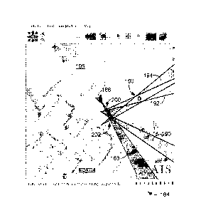
four lines of bearing 188-194 intersect in three possible places 198, 200,
202. In this
situation, one or more of the lines of bearing 188-194 may be removed from the
location
determination if it is thought to be an erroneous line of bearing. The
suspected line of
bearing could be selected from the GUI 184 or from an additional GUI 204 such
as the
one illustrated in FIG. 12. FIG. 12 illustrates another embodiment of a
graphical user
interface (GUI) 204 for use on an apparatus for locating a target wireless
device, wherein
information pertaining to one or more lines of bearing 188-194 may be
displayed,
selected, and/or cleared. In this example, line of bearing 192 is selected to
be ignored in
the location determination. The result is illustrated in the GUI 206 of FIG.
13 where a
clear location of the target wireless device is indicated by the intersection
208 of the three
remaining lines of bearing 188, 190, and 194. The GUI 206 may also be equipped
with a
18
CA 02761818 2011-11-09
WO 2010/138560
PCT/US2010/036161
direction indicator 210 and a distance indicator 212 from the current position
214 to the
target wireless device to assist an operator with navigating to the target
wireless device.
[00054] FIGS. 14A-14D illustrate further embodiments of a graphical user
interface
for use on an apparatus for locating a target wireless device. The graphical
user interface
of FIG. 14A illustrates an embodiment of a device list configured to display
information
identifying one or more wireless devices. The graphical user interface of FIG.
14B
illustrates an embodiment of bearing information for a directional antenna.
The graphical
user interface of FIG. 14B also is able to use the up and down arrows to
select one or
more of the identified wireless devices from FIG. 14A as the target wireless
device and
has a lock control configured to be used with the selected target wireless
device in order
to initiate the determination of one or more lines of bearing towards the
target wireless
device. The graphical user interface of FIG. 14C illustrates an embodiment of
a graphical
user interface in a lock mode initiated by the lock control of FIG. 14B. In
FIG. 14C, the
lines without an arrow in the center circle indicate signal strength readings
and the angle
in which they were received. The arrow in the circle indicates which direction
is north.
The "4PKT" is the number of frames that have been collected for the Line of
Bearing
algorithm. The "Mark" button sets the line of bearing of a current position.
The graphical
user interface of FIG. 14D illustrates an embodiment of a coordinate display
configured
to show a location of the target wireless device as determined from a
plurality of the one
or more lines of bearing. Furthermore, the graphical user interface of FIG.
14D has a
direction indicator configured to show the direction from a current position
to the target
wireless device and a distance indicator configured to show a distance from
the current
position to the target wireless device.
[00055] FIG. 15 schematically illustrates one embodiment of a system 216
for
locating a target wireless device. The system 216 has a first mobile location
device 218
and a second mobile location device 220. Each mobile location device 218, 220
has a
processor (P), a directional antenna (DA), a positioning system (PS), a
compass (C), a
user interface (UI), and an optional data storage (DS), the features of which
have been
discussed above. The first and second mobile location devices 218, 220 may be
moved
into desired, but separate sensing locations where a first line of bearing 222
may be
determined by the first mobile location device 218 and a second line of
bearing 224 may
19
CA 02761818 2011-11-09
WO 2010/138560
PCT/US2010/036161
be determined by the second mobile location device 220 using the methods
described
above or their equivalents. In the location system 216, the first mobile
location device
218 and the second mobile location device 220 are coupled 226 so that the
first and
second lines of bearing 222, 224 may be shared to determine an intersection
228 where
the target wireless device is located. Although only two location devices have
been
illustrated in this example for simplicity, it should be noted that other
systems may have
more than two location devices.
[00056] FIG. 16 schematically illustrates another embodiment of a system
230 for
locating a target wireless device. The system 230 has a first mobile location
device 232
and a second mobile location device 234. Each mobile location device 232, 234
has a
processor (P), a directional antenna (DA), a positioning system (PS), a
compass (C), a
user interface (UI), and an optional data storage (DS), the features of which
have been
discussed above. The first and second mobile location devices 232, 234 may be
moved
into desired, but separate sensing locations where a first line of bearing 236
may be
determined by the first mobile location device 232 and a second line of
bearing 238 may
be determined by the second mobile location device 234 using the methods
described
above or their equivalents. In the location system 230, the first mobile
location device
232 and the second mobile location device 234 are coupled by a remote
processor 240 so
that the first and second lines of bearing 236, 238 may be shared to determine
an
intersection 242 where the target wireless device is located. The processors
(P) of the
first and second mobile location devices 232, 234 may or may not be capable of
determining the intersection 242 of the lines of bearing from other location
devices,
however, the remote processor 240 may be configured to handle this
determination. In
this situation, the intersection 242 information may be passed back to one or
more of the
mobile location devices 232 and or displayed on an optional user interface 244
coupled to
the remote processor 240. Furthermore, an optional data storage 246 may be
coupled to
the processor 240 for storage of information collected during the location
process.
Although only two location devices have been illustrated in this example for
simplicity,
it should be noted that other systems may have more than two location devices.
[00057] FIG. 17 schematically illustrates one embodiment of a system 248
for
locating a target wireless device. The system 248 has a first mobile location
device 250
CA 02761818 2011-11-09
WO 2010/138560
PCT/US2010/036161
and a first fixed location device 252. The first mobile location device 250
has a
processor (P), a directional antenna (DA), a positioning system (PS), a
compass (C), a
user interface (UI), and an optional data storage (DS), the features of which
have been
discussed above. The first fixed location device 252 has a compass (C) and a
directional
antenna (DA) which can be manually adjusted to aim in a single direction, or
dynamically beam-swept through a field of view, or electromechanically swept
through a
field of view. The first fixed location device 252 has an optional positioning
system
(PS), since the position of the first fixed location device may already be
known by the
first mobile location device 250. Alternatively, the first fixed location
device 252 may
have a positioning system (PS) which either functions as described in previous
embodiments or one which is simply an internally settable location programmed
as part
of an installation or calibration of the first fixed location device 252. The
first fixed
location device 252 may have an optional user interface (UI), but does not
need one,
since an operator is not necessarily needed at the fixed location. The first
fixed location
device 252 may also have an optional data storage (DS), the features of which
have been
discussed above. The first mobile location devices 250 may be moved into
desired
location separate from the location of the first fixed location device 252. A
first line of
bearing 254 may be determined by the first mobile location device 250 and a
second line
of bearing 256 may be determined by the first fixed location device 252 using
the
methods described above or their equivalents. In the location system 248, the
first mobile
location device 250 and the fixed mobile location device 252 are coupled 258
so that the
first and second lines of bearing 254, 256 may be shared to determine an
intersection 260
where the target wireless device is located. Although only two location
devices have
been illustrated in this example for simplicity, it should be noted that other
systems may
have more than two location devices.
[00058] FIG. 18 schematically illustrates one embodiment of a system 262
for
locating a target wireless device. The system 262 has a first mobile location
device 264
and a first fixed location device 266. The first mobile location device 262
has a
processor (P), a directional antenna (DA), a positioning system (PS), a
compass (C), a
user interface (UI), and an optional data storage (DS), the features of which
have been
discussed above. The first fixed location device 266 has a compass (C) and a
directional
21
CA 02761818 2011-11-09
WO 2010/138560
PCT/US2010/036161
antenna (DA) which can be manually adjusted to aim in a single direction, or
dynamically beam-swept through a field of view, or electromechanically swept
through a
field of view. The first fixed location device 266 has an optional positioning
system
(PS), since the position of the first fixed location device may already be
known by the
first mobile location device 264 or a remote processor 268 which couples the
first mobile
location device 264 and the first fixed location device 266 together. As
described above,
the remote processor 268 may have an optional user interface 270 and/or a data
storage
272. Alternatively, the first fixed location device 266 may have a positioning
system
(PS) which either functions as described in previous embodiments or one which
is simply
an internally settable location programmed as part of an installation or
calibration of the
first fixed location device 266. The first fixed location device 266 may have
an optional
user interface (UI), but does not need one, since an operator is not
necessarily needed at
the fixed location. The first fixed location device 266 may also have an
optional data
storage (DS), the features of which have been discussed above. The first
mobile location
devices 264 may be moved into desired location separate from the location of
the first
fixed location device 266. A first line of bearing 274 may be determined by
the first
mobile location device 264 and a second line of bearing 276 may be determined
by the
first fixed location device 266 using the methods described above or their
equivalents. In
the location system 262, the first mobile location device 264 and the first
fixed location
device 266 are coupled by the remote processor 268 so that the first and
second lines of
bearing 274, 276 may be shared to determine an intersection 278 where the
target
wireless device is located. The processors (P) of the first mobile location
device 264 and
the first fixed location device 266 may or may not be capable of determining
the
intersection 278 of the lines of bearing from other location devices, however,
the remote
processor 268 may be configured to handle this determination. In this
situation, the
intersection 278 information may be passed back to the first mobile location
device 264
and/or the first fixed location device 266. Additionally, the intersection 278
information
may be displayed on the optional user interface 272 coupled to the remote
processor 268.
Although only two location devices have been illustrated in this example for
simplicity,
it should be noted that other systems may have more than two location devices.
22
CA 02761818 2011-11-09
WO 2010/138560
PCT/US2010/036161
[00059] FIG. 19 schematically illustrates one embodiment of a system 280
for
locating a target wireless device. The system 280 has a first fixed location
device 282
and a second fixed location device 284. The first and second fixed location
devices 282,
284 have a processor (P), a compass (C), and a directional antenna (DA) which
can be
manually adjusted to aim in a single direction, or dynamically beam-swept
through a field
of view, or electromechanically swept through a field of view. The first and
second fixed
location devices 282, 284 have an optional positioning system (PS), since the
position of
the first and second fixed location devices 282, 284 may already be known by a
remote
processor 286 which couples the first fixed location device 282 and the second
fixed
location device 284 together. As described above, the remote processor 286 may
have an
optional user interface 288 and/or a data storage 290. Alternatively, the
first and second
fixed location devices 282, 284 may have a positioning system (PS) which
either
functions as described in previous embodiments or one which is simply an
internally
settable location programmed as part of an installation or calibration of the
first and
second fixed location devices 282, 284. The first and second fixed location
devices 282,
284 may have an optional user interface (UI), but do not need one, since an
operator is
not necessarily needed at the fixed locations. The first and second fixed
location devices
282, 284 may also have an optional data storage (DS), the features of which
have been
discussed above. The first and second fixed location devices 282, 284 should
be located
in separate positions. A first line of bearing 292 may be determined by the
first fixed
location device 282 and a second line of bearing 294 may be determined by the
second
fixed location device 284 using the methods described above or their
equivalents. In the
location system 280, the first fixed location device 282 and the second fixed
location
device 284 are coupled by the remote processor 286 so that the first and
second lines of
bearing 292, 294 may be shared to determine an intersection 296 where the
target
wireless device is located. The processors (P) of the first and second fixed
location
devices 282, 284 may or may not be capable of determining the intersection 296
of the
lines of bearing from other location devices, however, the remote processor
286 may be
configured to handle this determination. In this situation, the intersection
296
information may be passed back to the first and/or second fixed location
devices 282,
284. Additionally, the intersection 296 information may be displayed on the
optional
23
CA 02761818 2011-11-09
WO 2010/138560
PCT/US2010/036161
user interface 288 coupled to the remote processor 286. Although only two
location
devices have been illustrated in this example for simplicity, it should be
noted that other
systems may have more than two location devices.
[00060] FIG. 20 schematically illustrates one embodiment of a system 298
for
locating a target wireless device. The system 298 has a first fixed location
device 300
and a second fixed location device 302. The first fixed location device 300
has a
processor (P), a compass (C), a directional antenna (DA), a user interface
(UI), and an
optional data storage (DS), the features of which have been discussed above.
The second
fixed location device 302 has a compass (C) and a 'directional antenna (DA)
which can
be manually adjusted to aim in a single direction, or dynamically beam-swept
through a
field of view, or electromechanically swept through a field of view. The first
and second
fixed location devices 300, 302 have an optional positioning system (PS),
since the
position of the first and second fixed location devices 300, 302 may already
be.
Alternatively, the first and second fixed location devices 300, 302 may have a
positioning
system (PS) which is simply an internally settable location programmed as part
of an
installation or calibration of the first and second fixed location devices
300, 302. The
second fixed location device 302 may have an optional user interface (UI), but
does not
need one, since an operator is not necessarily needed at each fixed location.
The second
fixed location device 302 may also have an optional data storage (DS), the
features of
which have been discussed above. The first and second fixed location devices
300, 302
are located separately from each other. A first line of bearing 304 may be
determined by
the first fixed location device 300 and a second line of bearing 306 may be
determined by
the second fixed location device 302 using the methods described above or
their
equivalents. In the location system 298, the first fixed location device 300
and the
second fixed mobile location device 302 are coupled 308 so that the first and
second lines
of bearing 304, 306 may be shared to determine an intersection 310 where the
target
wireless device is located. Although only two location devices have been
illustrated in
this example for simplicity, it should be noted that other systems may have
more than two
location devices.
[00061] Location monitoring systems may be installed around corporate,
university,
or military campuses, and could even be installed for entire cities or
countries. Such
24
CA 02761818 2016-04-06
WO 2010/138560 PCT/US2010/036161
systems could be used to detect wireless "intruders", locate machines
conducting criminal
activity, or locate known "criminal" machines (by monitoring for known MAC
addresses,
alerting when one is detected, and specifying where it is).
1000621 The disclosed location apparatus and/or methods or their
equivalents could be
integrated into wireless access points, for example into a CISCO (R..) LinkSys
Ctf) router, for
cooperation with other fixed or mobile location devices to show how many
machines are
connected to the access point and their physical locations. Such devices could
optionally
be configured to send an intruder alert to the network owner, administrator,
or law
enforcement. Functionally, such devices could also be configured to allow an
administrator to set a virtual perimeter for their access point, regardless of
the actual
coverage area, whereby wireless devices outside of that virtual perimeter
would not be
allowed to connect from outside the virtual perimeter. Alternatively,
advertising or other
messaging may be sent to any machine that attempts to connect from outside the
virtual
perimeter (or inside it, or from any defined geography within range of the
access point).
[00063] The disclosed embodiments and their equivalents could be used by
Internet
Service Providers to monitor for theft of service by installing the location
apparatus in
service vehicles and driving through a service area.
1000641 The disclosed embodiments and their equivalents could be used in
conjunction with subscriber or free hot-spots being offered in some locations
in order to
collect usage data by wireless device location and/or route advertising by
physical
location within the hot zone.
1000651 As mentioned in the background, terrorists are frequently using
cell phones
or other wireless devices to detonate improvised explosive devices (1ED's).
The
disclosed embodiments and their equivalents could bc used by the military or
law
enforcement officers to locate IED controllers equipped with wireless
technology and/or
the wireless remote detonator.
1000661 Having thus described several embodiments of a method and system
for
locating a target wireless device, it will be rather apparent to those skilled
in the art that
thc foregoing detailed disclosure is intended to be presented by way of
example only.
Various alterations, improvements, and modifications will occur and are
intended to those skilled in the art. These alterations,
CA 02761818 2016-04-06
WO 2010/138560 PCT/US2010/036161
improvements, and modifications arc intended to be suggested hereby.
For example, although the embodiments
discussed herein have been focused on using antenna sweeps which are
substantially
horizontal, it is possible to perform the same analysis using antenna sweeps
which are not
horizontal or purely horizontal. An azimuth system could be used in some
embodiments
to determine a set of elevation information during antenna sweeps. In such an
embodiment, a line of bearing to a target wireless device could also have an
elevation
component for assistance in locating target wireless devices with more
accuracy.
Additionally, the recited order of the processing elements or sequences, or
the use of
numbers, letters, or other designations therefore, is not intended to limit
the inventive
processes to any order except as may be specified.
26